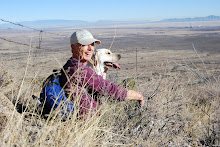
 Today was Anneke's foray into Tucson for groceries, so Emma and I continued with our tradition of taking a hike while Anneke performed this loathsome task. Emma and I have come up with a plan of scaling all the small hills around our canyon that are less than 6000' elevation. Looking on the topo map, we picked this particular nearby hill. It is next in sequence after Blacktail and a smaller hill west of Blacktail. Since the new hill is unnamed, Emma followed the best military tradition and named it after it's elevation: Hill 5445.
Turns out that it was a relatively easy hike. Going out was up, coming back was down. Pretty straightforward. Nevertheless, the AZ weather cooperated beautifully. We left in brilliant sunshine wearing a sweater that was shed before we reached the forest boundary. After following FR795 for a mile or so, we cut across country and straight up Hill 5445. The climb was less strenuous than Blacktail, but we finished higher. The last 100 feet in elevation was a little nasty because of the dense growth of agave, prickly pear and ocotillo. Picking a safe path was sometimes a challenge. Poor Emma came back with a prickly pear thorn in her side. Still, the view from the top was worth it.
Looking west towards the next challenge. If the hills weren't in the way, you could see Tucson.
 Looking north towards the windmill (a favorite riding destination).

1 comment:
Hi Anneke, thank you for coming to visit my blog. I stumbled upon your blog by clicking the Next Blog button! I especially like the idea that you uprooted yourself for adventure and recognize that you are living the life you want. I thought your blog was inspiring in a very earthy way. Hope you don't mind me checking in. Please feel free to visit me in return (or not, your choice).
Angela
Post a Comment