
Our destination on this lovely Monday morning was Blacktail. We have hiked to the top a number of times, or at least Dan has, but not with our new GPS. Note that I write "hiked", whereas previously I wrote "climbed". This means I must be getting used to these steep hillsides. This is the first time that I really got to the very top, where there is a jar and a pencil and paper so you can record your feat. I must admit that I did have to hum loudly to get up those last 15 feet of big rocks, a sign that I am truly freaked out.

It is interesting that the south side of the hill, from which we approach leaving from our back door, is all sedimentary pudding rock, with spectacular veins of red, white, and yellow, but the steeper north west side which we used for our descent is all red sandstone. Another notch in our GPS belt, and another hike recorded on Google Earth.


 Our destination on this lovely Monday morning was Blacktail. We have hiked to the top a number of times, or at least Dan has, but not with our new GPS. Note that I write "hiked", whereas previously I wrote "climbed". This means I must be getting used to these steep hillsides. This is the first time that I really got to the very top, where there is a jar and a pencil and paper so you can record your feat. I must admit that I did have to hum loudly to get up those last 15 feet of big rocks, a sign that I am truly freaked out.
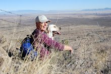


1 comment:
How wonderful to tour this beautiful land with you.
Post a Comment