The original plan today was to see if we could approach Council Rocks from the north side as it would be much shorter than our trip a couple of weeks ago. We did not make it very far as, shortly out of Dragoon, we came across a sign for Dragoon Spring, and decided to explore.
 On the way to Dragoon Spring is a turnoff for Dragoon Spring Station which was the westernmost stone fortified stage stop in the Butterfield Overland Mail Route. The station, in the heart of Apache country, was used from 1858 until 1862. The stone ruins are still there.
 After the stage coach stop we drove on to Jordan Valley "road" and finally abandoned Subie and continued on foot. Dragoon Spring is dry now, or at least it was today, but it is supposed to be the site of the signing of the peace treaty by Cochise and General Howard.
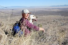
  I thought I recognized a rock outcropping that we had seen from our (east) side of the Dragoons so we hiked on to see if we could find a way across, or rather through, the mountains. Emma and I even went straight up the hill to reconnoiter, but the view was not clear and neither is the Google map. I would like to go back and walk through the wash and see if it connects with a known wash. This of course would not be in the monsoon season, but that is still about 10 weeks away. It would be spectacular to see the washes full of water, but it would be way too dangerous: flash flood extraordinaire.


No comments:
Post a Comment